Svalbard is best in hiking boots! And you don’t need to go far from the main street before you’re in the middle of the Arctic wilderness. There are many wonderful hikes just on the outskirts of town, or even IN town. Remember to always go on an organized tour with a guide who will take care of your safety. Some of these hikes are physically demanding, so please check out the level of difficulty before you decide which one to choose.
As we say in Norwegian - GOD TUR!
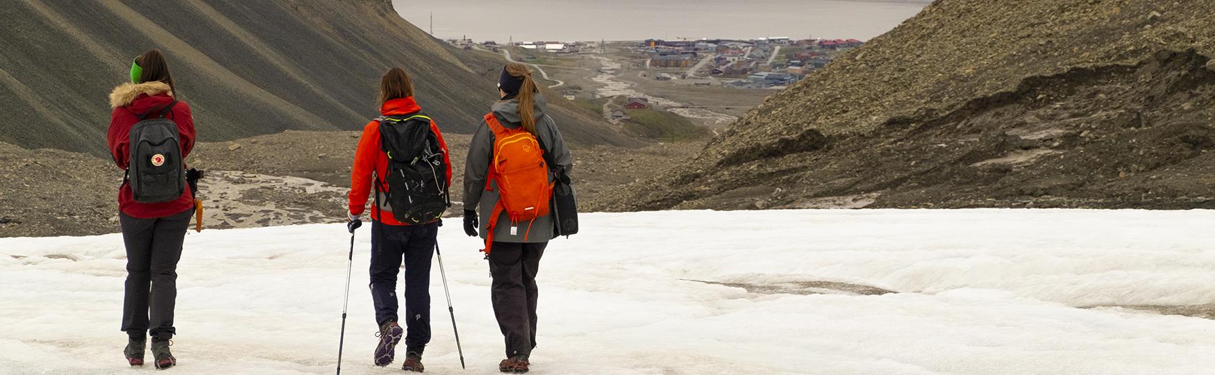
Varden and the Plateau Mountain
- A local favourite hike
This is a popular hike that locals do all the time, with great views of Longyearbyen. 400 meters above Longyearbyen is the Plateau Mountain, “Platåberget”. The route starts at the Cableway Central at Skjæringa. After the first 300 meters of climbing up a rocky path, you’ll find a cairn “Varden”. Already at this point you’ll have a wonderful view of Longyearbyen.
After the cairn you continue up 100 meters, to the Plateau Mountain. Here you might see some of Longyearbyen’s colourful flora, Svalbard reindeer and migratory birds. At the top of the climb you will be rewarded with fantastic views over Longyearbyen and the Isfjord, from 424 meters above sea level.
Note that the Plateau Mountain is outside the safe area for polar bears.
Duration: 3-6 hours
Level of difficulty: 3 - Demands average physical fitness, not suitable if you have limited mobility (uneven and partly steep terrain)

Hiorthfjellet Mountain
- An Arctic challenge on the other side of the fjord
The locals love their mountains, and especially Hiorthfjellet, which majestically rises in the backdrop of town.
The adventure starts with a kayak trip across the fjord before you’ll start climbing to the summit of Hiorthfjellet at 928 meters above sea level. On the summit you will be rewarded with probably the best view you’ve ever seen. Your nature guide will give you all necessary safety instructions, and you do not need any previous kayak experience to join this trip. But the hike is tough!
Note that the Hiorthfjellet Mountain is outside the safe area for polar bears.
Duration: 8-10 hours
Level of difficulty: 5 - Demands above average physical fitness, high level of physical activity over an extended period in uneven terrain
Trollsteinen Mountain
- Panoramic view of the Arctic wilderness
At the highest point of a ridge you’ll find a huge rock tower called “Trollsteinen” or the “Troll Rock”. Approximately 800 meters above sea level. The rock can be seen from town, and for many locals in Longyearbyen, this mountain peak is defined as a classic mountain hike - either by foot or by skis. On the way up and down, you’ll walk over the Larsbreen Glacier and explore some incredible moraine and icy landscape.
Note that Trollsteinen is outside the safe area for polar bears.
Duration: 8 hours
Level of difficulty: 4 – Demands good physical fitness, not suitable if you have limited mobility (steep, slippery and uneven terrain)
Sarkofagen Mountain
- Mountain between two glaciers
On each side of this characteristic mountain, there are some exciting glacier systems with moraines and meltwater channels. On your way to Sarkofagen, you will be able to explore these. The mountains is at 500 meters above sea level, and you’ll have a wonderful view on the top, of Longyearbyen and the Isfjord.
Note that Sarkofagen is outside the safe area for polar bears.
Duration: 4 hours
Level of difficulty: 3 - Demands average physical fitness, not suitable if you have limited mobility (uneven and partly steep terrain)
Nordenskiöldtoppen Mountain
- The highest peak in the vicinity of Longyearbyen
An Arctic challenge 1049 meters above sea level! A tough and long hike, but worth it when you get rewarded with the view! You’ll see how vast the fjord Isfjorden really is, and how small and far away Longyearbyen seems to be in Longyeardalen down below. You will observe flora, reindeer, birds and stone formations (polygons). On top you’ll have time for a long break and lunch. On the way back down to town, you’ll pass Sverdrupbyen, the oldest part of Longyearbyen.
Note that Nordenskiöldtoppen is outside the safe area for polar bears.
Duration: 8 hours
Level of difficulty: 4 - Demands good physical fitness, not suitable if you have limited mobility (steep, slippery and uneven terrain)
Lindholmshøgda Mountain
- Great views of the sea and the Adventfjord
You’ll start by walking along the historically interesting old cableway in the Advent Valley. The hike continues by the valley and the edge of Lindholmshøgda. On the top of Lindholmshøgda, 459 meters above sea level, you will get a beautiful view over the Adventfjord and the area of Longyearbyen. This mountain is great view point for the amazing Arctic sunsets!
Note that Lindholmshøgda is outside the safe area for polar bears.
Duration: 4 hours
Level of difficulty: 3 - Demands average physical fitness, not suitable if you have limited mobility (uneven and partly steep terrain)
“Off road” in the Advent Valley
- Along Longyearbyen’s fresh water pond
This trip starts by the old airport in the Advent Valley, and along the way you’ll have the best aspects of Longyearbyen’s nature and history. This hike is an “off-road hike” on the fascinating Arctic tundra. The terrain is flat and easy. You will follow the old cableway which was used to transport coal from the mines directly to the harbour. The chances are good of spotting some Svalbard reindeer, too. Since they have no natural predators in Svalbard, they are not very afraid of humans. The trip can be done all year round.
Note that this hike is outside the safe area for polar bears.
Duration: 4 hours
Level of difficulty: 2 – Suitable for most
Bjørndalen
- Close to the wildlife just outside of town
Bjørndalen is an area west of Longyearbyen with beatuiful nature. Here you will most likely come very close to flora and fauna. Reindeer and Arctic foxes are never far away. The terrain is flat and easy as you stroll along the ocean. Bjørndalen can be combined with a hike up to Fuglefjellet, "The Bird Mountain", where you can experience rich wildlife and and amazing view over the Isfjord.
Note that Bjørndalen is outside the safe area for polar bears.
Duration: 2-8 hours
Level of difficulty: 2 - Suitable for most (Fuglefjellet: 4 - Demands good physical fitness, not suitable if you have limited mobility (steep, slippery and uneven terrain))
Blomsterdalshøgda Mountain
- Nice view and mining history
Next to the airport, close to The Global Seed Vault lies Blomsterdalshøgda Mountain, a favorite among locals and visitors. This small mountain gives you a great view over the fjord, and at the plateu on top, you can enjoy lunch and a well deserved break. On the way up, you will pass the old coal mine "Mine 1A", also known as "the american mine".
Note that Blomsterdalshøgda mountain is outside the safe area for polar bears.
Duration: 3-5 hours
Level of difficulty: 3 - Demands average physical fitness, not suitable if you have limited mobility (uneven and partly steep terrain)
A walk in town
– Try out The City Loop!
One of the most popular hikes is “Byrunden”, which means “around the city”. This is the spot to meet locals and pass some of the most iconic buildings in Longyearbyen. You don’t need to worry about polar bear protection, because the outlines of “Byrunden” are within the safe area. The round is approximately 8 kilometres and takes you around our little arctic city. On your way you will get a closer look at the Svalbard Church, Taubanesentralen (the ropeway central), the legendary Huset, and the mountains surrounding us. You can start the walk from the city centre and go towards Nybyen, then via Huset and Skjæringa, back to the city centre.
Duration: 30 minutes or more!
Level of difficulty: 2 – Suitable for most